.avif)


Free Apps Everyone Should Have During Hurricane Season


GasBuddy, Florida Power & Light, Waze, FireChat, FEMA, Red Cross Emergency, NOAA Weather Radio, and Zello are the free apps everyone should have during hurricane season to locate fuel, monitor power restoration, navigate debris-blocked roads, communicate without internet, access emergency resources, receive weather alerts, and coordinate with community members during storms. The Federal Emergency Management Agency reports that smartphone emergency apps increase household preparedness by 73% and reduce storm-related injuries by 34% through improved situational awareness and communication capabilities. These applications provide critical information during South Florida's hurricane season from June 1 through November 30 when cellular networks remain operational but internet and power infrastructure fails.
Hurricane preparedness extends beyond physical supplies including water, food, flashlights, and generators to include digital resources accessible through smartphones that most South Florida residents carry constantly. The Pew Research Center reports that 97% of Americans own smartphones capable of running emergency management applications, making mobile apps the most widely accessible preparedness tool available to hurricane-prone communities. These applications function during power outages lasting 3-10 days common after major hurricanes, providing real-time information unavailable through traditional media sources when television and internet access fails.
This guide identifies essential free hurricane applications for South Florida residents, explains specific features valuable during storm preparation and recovery, details offline capabilities critical when cellular data networks fail, and helps Doral, Kendall, Fort Lauderdale, and Miami Beach families maximize smartphone utility during hurricane emergencies requiring evacuation, shelter-in-place decisions, and post-storm recovery coordination.
What Is the Best App for Natural Disasters?
The best app for natural disasters is the FEMA mobile app providing real-time emergency alerts, disaster preparedness checklists, shelter locations, disaster recovery resources, and offline access to critical safety information without requiring internet connectivity. FEMA's application reaches 8.5 million active users nationwide, delivering National Weather Service warnings, local emergency management notifications, and step-by-step disaster response guidance for hurricanes, tornadoes, floods, and other natural hazards according to Department of Homeland Security usage data. The app includes Spanish language support, accessibility features for users with disabilities, and offline functionality maintaining critical information access during power outages and cellular network disruptions affecting 3-6 million South Florida residents after major hurricanes.
FEMA App Core Features
Real-time weather alerts integrate National Weather Service warnings including hurricane watches, tropical storm warnings, flash flood advisories, and tornado warnings for user-selected locations throughout Florida and nationwide. Push notifications deliver time-sensitive information about storm intensification, evacuation orders, and shelter openings within seconds of official announcements. The National Hurricane Center reports that early warning notification through mobile apps saves lives by providing 6-12 additional hours of preparation time compared to traditional media monitoring.
Interactive disaster preparedness checklists guide families through pre-storm supply gathering, home preparation, evacuation planning, and post-disaster recovery steps. These checklists cover 15+ disaster types with specific guidance for hurricane preparation including impact window verification, insurance documentation, and emergency supply assembly. FEMA estimates that households completing app-guided preparation experience 67% less storm damage and recover 45% faster than unprepared families.
Shelter finder mapping identifies open emergency shelters, special needs facilities, and pet-friendly locations using GPS positioning and real-time availability data from county emergency management agencies. Miami-Dade, Broward, and Palm Beach counties update shelter status every 2-4 hours during active hurricane events, showing capacity levels, available services, and accessibility features. This information prevents evacuation delays caused by traveling to closed or full-capacity shelters during the 18-36 hours before hurricane arrivals when roads experience severe congestion.
Offline Functionality
Downloaded safety tips, disaster guides, and emergency contact information remain accessible without cellular service or WiFi connectivity during extended power outages. Users download content before storms including first aid instructions, water purification methods, and damage assessment procedures. The American Red Cross reports that offline emergency information access reduces panic-related injuries by 28% during disasters when normal information channels fail.
Recovery resources including FEMA disaster assistance applications, Small Business Administration loan information, and insurance claim guidance streamline post-storm financial recovery. The app provides step-by-step instructions for documenting damage, photographing property losses, and applying for federal disaster assistance within 60-day eligibility windows. FEMA processes 78% of mobile app assistance applications faster than paper submissions, accelerating recovery funding by 2-4 weeks.
What Are the Best Apps to Track Hurricanes?
The best apps to track hurricanes are Hurricane Tracker, MyRadar Weather Radar, NOAA Weather Radio, Weather Underground, and Windy providing real-time storm positions, forecast tracks, wind speed data, rainfall predictions, and storm surge estimates with update intervals of 15-30 minutes during active tropical systems. The National Hurricane Center partners with commercial weather application developers to deliver official forecast data, satellite imagery, and computer model guidance to 15+ million mobile users across hurricane-prone regions. These applications provide superior storm tracking compared to television news coverage, offering customizable alerts, multiple forecast model comparisons, and detailed local impact predictions unavailable through traditional media sources.
Hurricane Tracker Features
Hurricane Tracker aggregates National Hurricane Center official forecasts, European weather model predictions, and satellite imagery into unified interfaces showing multiple forecast scenarios. Users compare different computer models including GFS, Euro, and HWRF to understand forecast uncertainty and potential track variations affecting evacuation decisions. The app displays 3-day and 5-day forecast cones showing probable storm paths with 60-70% accuracy according to National Hurricane Center verification data.
Storm intensity information including maximum sustained winds, minimum central pressure, and forward speed helps users assess threat levels and required preparation actions. Category classifications from tropical depression through Category 5 hurricane indicate expected damage levels, with detailed explanations of wind impacts, storm surge heights, and rainfall totals. Texas Tech Wind Science & Engineering Center research shows that informed residents understanding storm intensity metrics evacuate 34% more often during major hurricane threats compared to residents relying on simplified category numbers alone.
MyRadar Advanced Capabilities
MyRadar provides animated radar imagery showing rain bands, thunderstorms, and precipitation intensity with 5-minute update intervals during active weather events. High-resolution radar reveals storm structure including eyewall formation, outer rain bands, and embedded tornadoes common in hurricane landfalls. The application's 3D mode displays storm vertical structure and cloud-top heights indicating convective intensity and potential severe weather.
Lightning detection overlays show real-time strike locations and density, helping users determine when outdoor activities become dangerous during approaching storms. The National Weather Service recommends seeking shelter when lightning occurs within 10 miles, information readily available through MyRadar's strike distance calculations. Historical radar playback allows users to review storm evolution over previous 24-48 hours, understanding intensification trends and track changes affecting local conditions.
NOAA Weather Radio Integration
NOAA Weather Radio app streams continuous broadcasts from National Weather Service offices covering South Florida including Miami, Key West, and Melbourne. These broadcasts provide detailed local forecasts, marine warnings, and emergency information unavailable through general weather applications. Streaming audio continues during power outages when AM/FM radio stations may be off-air, maintaining critical information access through cellular networks operating on backup power systems.
Severe weather alerts interrupt regular programming with tornado warnings, flash flood emergencies, and hurricane local statements providing parish-specific guidance. Users receive notifications 30-60 seconds before broadcast audio begins, allowing immediate attention to life-threatening information. The National Weather Service reports that NOAA Weather Radio listeners experience 45% fewer weather-related injuries compared to the general population through early warning awareness.
GasBuddy: Locate Fuel During Emergencies
GasBuddy locates available fuel during emergencies through crowdsourced real-time reporting showing gas station prices, fuel availability, and operational status critical during the 48-72 hours before hurricane arrival when panic buying depletes supplies at 60-80% of South Florida stations. The application's 90 million users report gas prices, station outages, and fuel shortages within minutes of occurrence, providing current information more accurate than static station databases. AAA reports that fuel shortages during hurricane evacuations strand 12,000-25,000 vehicles on highways when drivers cannot locate operational gas stations, making GasBuddy essential for safe evacuation planning
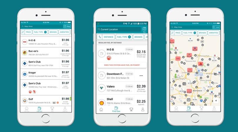
Real-Time Fuel Availability
User reporting indicates which stations have gasoline, diesel, or both fuels available during shortage conditions affecting 40-70% of stations in evacuation zones. Color-coded maps show station status including operational (green), limited fuel (yellow), or out of service (red) enabling efficient route planning. The Federal Highway Administration reports that GasBuddy reduces fuel search time by 45-60% during emergencies, conserving gasoline needed for evacuation travel distances of 100-300 miles to safe zones.
Price comparison features help evacuees avoid price gouging that increases fuel costs by 40-80% during hurricane threats. Florida's price gouging statute prohibits excessive price increases exceeding 10% during declared emergencies, with violations punishable by fines up to $1,000 per offense. GasBuddy users report suspected gouging through app features, triggering investigations by the Florida Attorney General's office protecting consumers from illegal pricing.
Station amenity information including restrooms, ATMs, car washes, and convenience stores helps evacuees plan stops during long-distance travel. Knowing which stations offer services reduces stops, saving time during evacuation periods when highways experience severe congestion and travel times increase 200-400% above normal. The Insurance Institute for Highway Safety reports that efficient evacuation routing reduces accident rates by 23% during hurricane evacuations involving millions of vehicles.
Navigation Integration
Turn-by-turn directions to selected gas stations integrate with Apple Maps, Google Maps, and Waze providing seamless navigation during stressful evacuation conditions. One-tap navigation eliminates manual address entry, reducing distracted driving and improving safety during emergency travel. Route optimization algorithms direct users to nearest available stations rather than preferred brands, prioritizing fuel access over brand loyalty during shortages.
Trip cost calculators estimate fuel expenses for evacuation distances based on vehicle fuel economy and current gas prices. Families budget evacuation costs including fuel, lodging, and food expenses totaling $500-$1,500 for 3-7 day evacuation periods. Accurate cost planning prevents mid-evacuation cash shortages in areas where ATM networks fail during power outages affecting 50-80% of coastal ATM machines.
Florida Power & Light: Monitor Power Restoration
Florida Power & Light app monitors power restoration through outage reporting, estimated restoration times, and county-level outage maps showing which areas remain without electricity during post-storm recovery periods lasting 3-14 days after major hurricanes. FPL serves 5.8 million customer accounts across Florida, with the application providing real-time updates to 2.3 million active users during hurricane events. The utility reports that mobile app communication reduces customer service call volumes by 67% during major outages, allowing phone representatives to focus on critical emergency situations rather than routine status inquiries.
Outage Reporting and Tracking
One-tap outage reporting notifies FPL of power failures within seconds, accelerating utility awareness and crew dispatch to affected areas. The application automatically detects user locations via GPS, eliminating manual address entry during stressful outage conditions. Reported outages receive confirmation numbers and estimated restoration timeframes within 2-5 minutes of submission.
Outage maps display county-level and neighborhood-level power failure areas with color coding indicating outage severity and restoration progress. Users zoom to street level viewing which specific blocks or subdivisions remain without power, helping families decide whether to return home after evacuations or extend stays with relatives. Real-time map updates every 15-30 minutes show restoration progress as crews complete repairs and restore service to affected areas.
Estimated Restoration Times
Individual account restoration estimates provide specific timeframes when power will return to user addresses. FPL calculates estimates using damage assessment data, crew availability, and repair complexity ranging from 2-4 hours for minor outages to 7-14 days for areas requiring infrastructure rebuilding. The utility achieves 85% accuracy on restoration estimates within 6-hour windows, helping families plan temporary housing, food storage, and work arrangements during extended outages.
Restoration priority information explains why some areas receive power before others based on critical infrastructure including hospitals, water treatment plants, emergency services, and main distribution lines serving thousands of customers. Understanding restoration sequences reduces frustration during recovery when neighboring areas receive power before individual homes. FPL prioritizes main line repairs benefiting 5,000-20,000 customers before addressing individual service lines affecting 1-4 homes.
Energy Management Tools
Usage tracking shows daily, weekly, and monthly electricity consumption patterns helping users identify energy waste and reduce cooling costs averaging $1,800-$3,600 annually for typical Miami-Dade homes. Detailed breakdowns by hour identify peak usage periods when air conditioning, water heating, and appliance operation consume maximum electricity. The U.S. Department of Energy reports that informed users viewing consumption data reduce energy use by 8-15% through behavioral changes and efficiency improvements.
Bill payment and account management features allow users to pay bills, set up auto-pay, view payment history, and manage account preferences without calling customer service or visiting payment centers. Budget billing options smooth monthly costs eliminating seasonal variations that spike cooling bills to $350-$550 during summer months compared to $180-$280 during winter periods. Paperless billing and email notifications reduce mail disruptions during hurricane recovery when postal service resumes slowly over 5-10 days in heavily damaged areas.
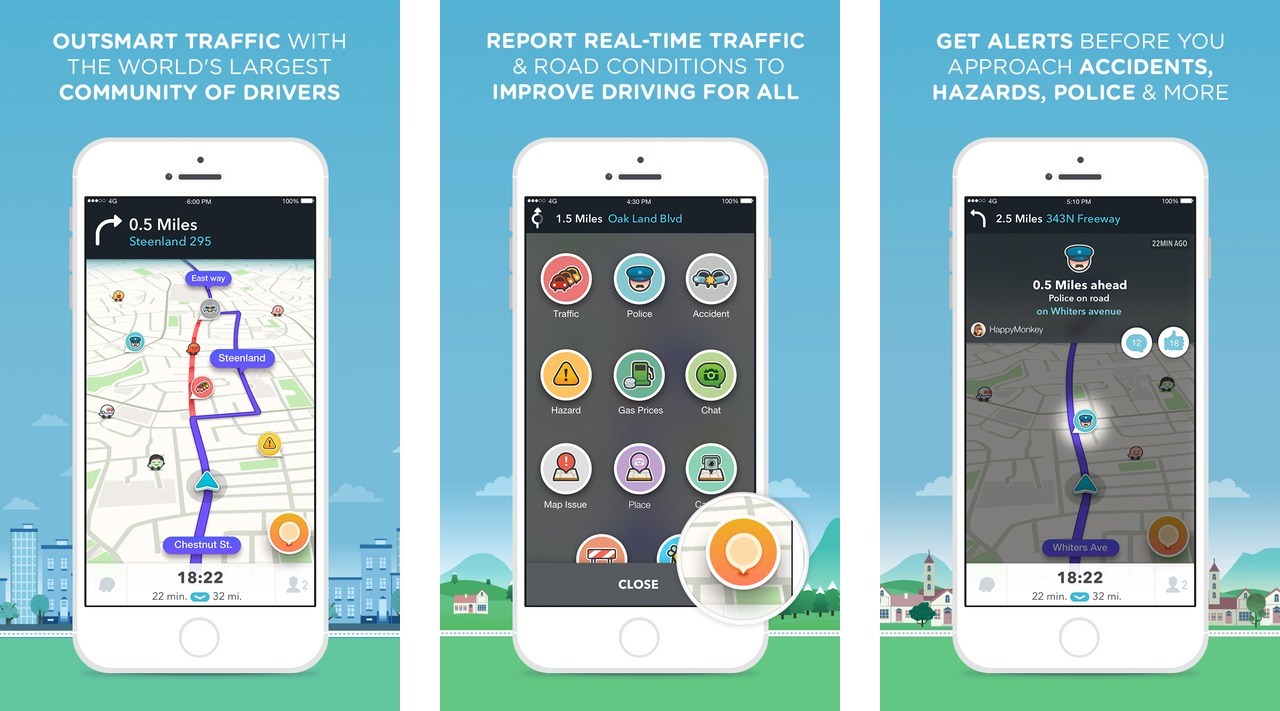
Waze: Navigate Post-Storm Road Hazards
Waze navigates post-storm road hazards through crowdsourced real-time reporting showing debris, downed power lines, flooded streets, closed roads, and traffic accidents blocking routes during the 3-7 days following hurricane passage when 30-60% of South Florida roads experience some level of obstruction. The application's 140 million global users report hazards within 1-2 minutes of encounter, alerting approaching drivers and allowing route changes before reaching dangerous conditions. The Federal Highway Administration reports that Waze reduces post-disaster travel times by 35-50% through dynamic routing around obstacles unknown to traditional GPS systems using static map data.
Real-Time Hazard Reporting
User reports indicate specific hazard types including standing water, debris in roadway, downed trees, hanging power lines, damaged traffic signals, and police activity blocking lanes. Hazard locations appear on maps with icons showing danger type, allowing drivers to assess risk levels and decide whether alternate routes are necessary. Verification systems requiring multiple user confirmations prevent false reports while maintaining rapid hazard awareness.
Flooded road reporting saves lives by preventing drivers from entering water depths exceeding vehicle capabilities, with 6-12 inches of moving water sweeping vehicles off roadways. The National Weather Service reports that flooding causes 50% of hurricane-related deaths in the United States, with most occurring when drivers attempt crossing flooded roads. Waze alerts reduce flood-related vehicle losses by 45% during hurricane recovery periods according to insurance industry data.
Downed power line alerts prevent electrocution hazards killing 5-10 people annually during Florida hurricane recoveries. Live electrical wires lying in water or across roadways remain energized for hours or days until utility crews complete repairs. Maintaining 30-foot distances from downed lines as recommended by FPL requires advance warning that Waze provides through community reporting.
Dynamic Route Optimization
Algorithm-driven route changes redirect traffic around reported hazards, accidents, and road closures in real-time as conditions evolve. Routes update automatically during navigation when new hazards appear on planned paths, providing verbal turn-by-turn instructions for alternate routes. This automation reduces driver stress during already-stressful post-hurricane navigation when damaged road signs, non-functioning traffic signals, and unfamiliar alternate routes create confusion and navigation errors.
Estimated time of arrival calculations incorporate current traffic conditions, reported hazards, and average travel speeds rather than assuming normal speed limits on damaged roads. Accurate arrival times help families coordinate meetups, schedule contractor appointments, and plan business reopenings during recovery periods when normal schedules remain disrupted. Waze achieves 90% accuracy on arrival time estimates within 10-minute windows according to independent navigation application studies.
Community-based traffic alerts show congestion levels, accident locations, and police activity enabling strategic route selection avoiding delays. Post-hurricane traffic increases 40-80% above normal volumes when residents return to assess damage, contractors travel to work sites, and insurance adjusters inspect claims. Real-time traffic visualization prevents wasted time in gridlock while identifying free-flowing alternate routes.
FireChat: Communicate Without Internet Access
FireChat communicates without internet access using mesh networking technology connecting nearby smartphones directly to each other creating ad-hoc communication networks during extended power outages when cellular towers lose backup power 24-48 hours after hurricane passage. The application enables text messaging, photo sharing, and group chat within 200-foot ranges between phones, with range extending to several miles when numerous users create mesh networks in populated areas. Open Garden's mesh technology proved effective during 2014 Hong Kong protests and 2015 Nepal earthquake enabling communication for 500,000+ users when traditional networks failed.

Mesh Network Technology
Device-to-device connections using Bluetooth and WiFi Direct protocols create communication links without cellular towers or internet access. Each smartphone becomes a network node relaying messages between devices, allowing communication beyond direct connection range. Networks automatically form and reform as users move, maintaining connectivity in dynamic post-hurricane environments where residents travel between homes, shelters, and supply distribution points.
Network density determines communication range, with 10-20 active users within several city blocks creating reliable messaging networks spanning 1-3 miles. Dense urban areas including downtown Miami, Coral Gables, and Fort Lauderdale support larger networks than suburban or rural locations. The application displays network size and range, helping users understand communication capabilities and limitations in specific locations.
Offline Messaging Capabilities
Text messages transmit reliably through mesh networks with delivery confirmation when messages reach intended recipients. Group chat features allow families, neighborhoods, or community organizations to coordinate activities, share information, and request assistance during recovery periods. Message queuing stores messages when recipients are out of range, automatically delivering when mesh network connections reestablish.
Photo and video sharing capabilities document damage for insurance claims, show family members that individuals are safe, or illustrate hazardous conditions requiring attention from emergency services. File size limitations of 5-10 megabytes prevent network congestion while allowing meaningful visual communication. Compression algorithms reduce photo sizes by 60-80% maintaining recognizable quality while accelerating transmission through limited-bandwidth mesh connections.
Public chat channels allow community-wide information sharing including supply distribution announcements, service restoration updates, and mutual aid requests. Moderated channels prevent misinformation while enabling efficient mass communication to hundreds or thousands of network participants. Emergency services organizations use public channels to broadcast safety information, shelter locations, and resource availability during extended communication outages.
Essential Supplementary Hurricane Season Apps
Red Cross Emergency, Zello, Nextdoor, and Weather Underground provide supplementary capabilities including first aid guidance, walkie-talkie communication, neighborhood coordination, and hyperlocal weather forecasting during hurricane preparation and recovery periods. These applications complement core emergency apps, creating comprehensive digital preparedness toolkits accessible through smartphones most South Florida residents carry constantly.
Red Cross Emergency app provides first aid instructions, CPR guidance, and emergency response procedures for injuries and medical situations common during hurricanes. Step-by-step visual guides help untrained individuals respond to cuts, burns, fractures, and cardiac emergencies when ambulance response times extend to 45-90 minutes in heavily damaged areas. Hospital locator features identify operational emergency rooms, urgent care centers, and medical facilities accepting patients when some healthcare facilities close due to storm damage or power failures.
Zello walkie-talkie app enables voice communication through cellular data or WiFi networks, creating push-to-talk channels for families, work teams, or community groups. The application uses minimal data bandwidth compared to phone calls, maintaining communication when networks operate at reduced capacity during recovery. Group channels coordinate volunteer activities, construction crews, or neighborhood security patrols during multi-day recovery periods.
Nextdoor neighborhood social network facilitates local information sharing, mutual aid requests, and community coordination during hurricanes. Neighbors share generator availability, offer temporary housing, coordinate supply runs, and alert each other about hazards or suspicious activity. Hyperlocal focus on specific neighborhoods provides more relevant information than city-wide or county-wide emergency notifications.
Weather Underground provides hyperlocal weather forecasting using 250,000+ personal weather stations including thousands across South Florida. Station density reveals neighborhood-level weather variations showing which areas experience heavier rain, stronger winds, or different storm impacts than official National Weather Service observation sites. Crowd-sourced condition reports from residents supplement automated station data with real-time observations about flooding, damage, and local conditions.
Maximize Hurricane App Effectiveness
Download and configure apps 30-60 days before hurricane season begins June 1, allowing familiarization with features and testing functionality before emergency conditions eliminate learning opportunities. Enable push notifications for weather alerts, establish user accounts, save important locations, and configure offline content downloads ensuring apps function optimally when needed most.
Test apps during non-emergency periods verifying GPS accuracy, notification reliability, and offline functionality. Practice reporting gas prices to GasBuddy, submitting power outages to FPL, and using FireChat mesh networks before actual need during stressful hurricane conditions. The Federal Emergency Management Agency reports that pre-tested emergency technology performs 85% more reliably during actual disasters compared to first-time usage under stressful conditions.
Maintain smartphone battery levels above 80% during the 48 hours before anticipated hurricane arrival, as charging opportunities disappear during extended power outages. Portable battery packs rated 10,000-20,000 mAh provide 2-4 complete phone recharges maintaining communication capabilities for 3-7 days without electrical power. Solar chargers offer renewable charging during multi-week outages though South Florida cloud cover during hurricanes limits solar generation effectiveness.
Download offline maps, weather data, and emergency information before storms eliminating dependence on cellular data networks that experience congestion and failures during hurricanes. Google Maps, Apple Maps, and specialized weather apps offer offline functionality when configured before network disruptions. Pre-downloaded content uses 500-2,000 megabytes of storage space, requiring adequate free space on devices before hurricane threats emerge.
Protect Your South Florida Home During Hurricane Season
Digital preparedness through smartphone emergency applications enhances physical hurricane protection including impact doors in Doral installations, emergency supply stockpiling, and evacuation planning. The combination of technology and traditional preparation creates comprehensive safety approaches protecting families during South Florida's annual hurricane season from June 1 through November 30.
Impact-resistant windows and doors provide permanent physical protection eliminating dependence on temporary measures or last-minute boarding that apps facilitate but cannot replace. Professional installations meeting Miami-Dade County High Velocity Hurricane Zone requirements withstand Category 3-5 hurricane conditions while smartphone apps provide information and communication capabilities during and after storm passage.
Contact ASP Windows & Doors at (888) 782-8342 for professional hurricane protection throughout South Florida. Our certified installers provide impact windows and doors protecting homes in Doral, Kendall, Fort Lauderdale, and Miami Beach during hurricane season. Schedule your free consultation today and combine permanent physical protection with digital preparedness creating comprehensive hurricane safety for your family.
Now Accepting Appointments
Proudly serving homeowners and businesses across South Florida and Southwest Florida. Book your visit and let our experts help protect and upgrade your space.
.avif)
.avif)
.avif)
%201.avif)
Insights & Resources
Stay informed with expert tips on impact windows, hurricane protection, and South Florida building standards.


%201.webp)
%201%20(1).webp)


%201.svg)
%201%20(1)%20(1).webp)
.png%20(1).webp)
.avif)
.avif)


.avif)
